Friday, October 14, 2011

Back to Auckland for the Semi-Finals

We're back in Auckland for the final few days.  Went to the history museum, Waiheki Island, Mt. Hobson Park, and then the two rugby semi-final matches.


Waiheki Island is stunning.  It's about a half-hour ferry ride from downtown Auckland, and home to wineries, beaches, olive groves, and very expensive homes.  You can see downtonw Auckland in the picture above if you enlarge it.


Downtown from a park near the History Museum.


Looking towards downtown from Mt. Hobson Park.


Also from Mt. Hobson, this is Rangitoto Island, a scenic preserve.  It's about 850 feet tall, 3 miles across, and it grew out of a volcano that erupted in the middle of the bay about 700 years ago.


France beat Wales in the first semi-final.  A key player from Wales was thrown out of the game for making a controversial tackle, and they had to play a man down for more than half the match.  The ref called it exactly as the rules require, but wow, in a semi-final match for the World Cup?


I'm sure that everybody's favorite match was NZ vs. Australia.  Can't beat the atmosphere for this one.  Talk about a home-field advantage, though.  Australia hasn't won a match at Eden Park in 20 years.

Looking back on it all, I can only say that this has been the trip of a life-time.  I hiked some of the most beautiful scenery in the world, watched the highest level of rugby played in the sport's most revered stadium, and shared it all, including great food and drink, with my best friends and rugby teammates that I've known for 25 years.

Doesn't get any better that that.


Thursday, October 13, 2011

Tane Mahuta

Heading south now, towards Auckland, we are only a short distance from the Wiapoua Forest, which is home to about three quarters of New Zealand's remaining mature kauri trees, including Tane Mahuta, the largest and oldest living kauri tree.  The name means Lord of the Forest, and the tree is estimated to be up to 2,500 years old.  It is 168 feet tall, and the trunk has a girth of just over 45 feet.


Kauri wood has some amazing characteristics - no knots, a beautiful color and grain, and it doesn't rot.  It's no longer legal to harvest kauri trees, so they dig up old tree trunks and recycle old buildings that were once made of kauri, and use the wood for high-end furniture and artworks.   Ancient tree trunks as much as 50,000 years old have been found in peat bogs, and their wood is perfectly preserved.

Hokianga Harbor

While in Paihia, we met a neat local Maori gentleman who was working as a tourist volunteer, providing information and helping out all the silly foreigners like us.  He said that was a direct descendant of one of the original Maori chiefs that signed the Treaty of Waitangi in 1840, essentially the founding document for New Zealand as a nation, and as colony of the British Empire.

We told him that we were looking for some neat things to see, and he pointed us to a little town called Opononi.  It's on the western coast, just east of the mouth of the Hokianga Harbor.  He said that this was the location of the first Maori settlement in New Zealand, and that there is a monument there, but that it is only open to Maori descendants.


We believe that this is the monument, but we couldn't find a way to get up there.  We asked a local if we could cross his property to hike up there, and while he didn't say that we couldn't go, he said that there were bulls there that were known to charge at people.  So, we decided to enjoy the view from the road.


Looking north across the Hokianga Harbor.  According to our guide, the first Maori to arrive in New Zealand paddled through here and established their first settlement nearby.


Looking north-east from the same location.


Looking east towards Opononi.


Looking south along the Tasman Sea (above).


Bay of Islands

We've got 5 days to play around now, so we went about 3 hours north to a little town called Paihia on the Bay of Islands.  It's about 50 miles from the northern-most tip of the North Island.  As the name would suggest, there are a bunch of small islands out in the bay, some have a few scattered homes, but most are uninhabited.


It's a beautiful spot, but once again, the weather wasn't being very cooperative.  Cool and drizzly.


We took this jet-boat out for a ride among the various islands, but clouds and mist rolled in to the point that we really couldn't see much, and the trip was cut short.


We did get to see Cook's Cove, which is on Motuarohia Island.  It's said to be the place where Captain James Cook first anchored upon his arrival to New Zealand on October 6, 1769.  In 1768, the 40 year-old Cook was chosen to lead a mission to the South Seas to observe the 1769 transit of Venus (they wanted to use the data to try and estimate the distance between the Earth and the Sun).  A separate and secret part of the mission, revealed to the crew only after they captured the information on the transit, was to search for evidence of unknown southern continents.  Cook and his crew were the second known Europeans explorers to visit New Zealand (after Able Tasman in 1642).  Cook arrived first at this spot, and then spent the next 6 months circumnavigating the islands.  He was the first to map the entire coastline of New Zealand.

Saturday, October 8, 2011

Auckland

It's about a 10-hour drive from Wellington to Auckland.  Oh well, it had to get done.

New Zealand has a population of about 4.4 million, and 1.4 million of them live in Auckland - over 30% of the population.  Rugby is their national sport, so it's exciting to be here for the World Cup.  We're staying in a really nice area called Remuera, which is about 3 miles south of downtown.


Eden Park is the Mecca of rugby here.  We watched France beat England in one quarter-final, and New Zealand beat Argentina in the other.


Pretty decent seats for the NZ - Argentina match.  What an experience!

Thursday, October 6, 2011

Able Tasman Natl. Park, the Cook Strait, and Wellington

Though we wanted to get an early start today, my buddy Dave was having a bit of an issue with his new camcorder, so it took some time to find an electronics shop and get that resolved.  On top of that, the road to Able Tasman is somewhat challenging - narrow, hilly, and twisting.  Put yourself in a 6-person motor-home while driving on the wrong side of the road, and it can be a little scary.  It's also the opposite direction from Picton, so we'll have to back-track.  But what the heck, this is probably the only time that we're going to get a chance to see it the Able Tasman National Park.


That's our motor-home above.  A 6-person configuration works pretty well for four rugby guys.


Looking east across the Tasman Bay and back toward Nelson, the mountains on the horizon are over 30 miles away.

It's about a 2 1/2 hour drive from Able Tasman to Picton, the port city were we're going to drive our motor-home onto the 6:00 pm ferry to Wellington.  The total fare for a vehicle and 4 passengers was something like $400, and since it's World Cup time, reservations are very limited.  It's a 4-hour cruise across the Cook Straight, and if we miss this boat, we'll probably miss the first two rugby matches in Auckland this weekend.  So, we didn't get to spend much time here at Able Tasman, but what we did see was beautiful.

The last several miles of the road to Picton is a beautiful twisty run along the Grove Arm of the Queen Charlotte Sound.  The boat ride through the sound and out into the Cook Straight is supposed to be magnificent.  Picton itself, however, seemed like a gritty little town, and when we got to the ferry landing, we found out that the boat was running 4 hours late.  Instead of arriving in Wellington at 10:00 pm, it now looks like it's going to be 2:00 am!

We walked over to the tourist area of downtown Picton, which was really quite nice, and found our way into the Picton RSA Club, which is kind of like a Veterans' lodge.  The RSA was founded by World War I vets, so it was full of old military guys.  We found a guy to "sponsor" our entry, and we enjoyed a good meal, cheep beer, and made a few friends.  

The 4-hour crossing turned into the trip from hell.  If I had know better, would have stayed in the motor-home and slept, but you're not really allowed to do that.  The passenger decks are pretty nice, and there's a bar and a few places to eat, but it's no different that being in an airport at 2:00 am.  Nobody really wants to be there.

Wednesday, October 5, 2011

Kaikoura, then over to Nelson

We headed up to Kaikoura, a cool little coastal town a few hours north of Christchurch.

It was dark when we arrived, but we found a great little restaurant, and our server happened to be a college student from Michigan.  She said that she recognized our "accents".

I'm sure that this is a beautiful little town, but it's rainy and a bit cold.  Not the best climate for the beach, so we decided to move on across to Nelson.  Even though it was overcast, the inland scenery was still beautiful.  We drove for hours, and hardly saw another vehicle on the road.

Nelson is on the northern tip of the South Island, and close to the Able Tasman National Park.  It was dark again when we arrived in Nelson this evening, and we're going to try and see the park in the morning before we head over to Picton to catch the ferry.  

Monday, October 3, 2011

Off to Christchurch

Flying to Christchurch today to meet up with the rest of my crew.  In a strange use of common sense, there was absolutely no security screening at the Queenstown airport before getting on this plane.  When I checked my bag, they said I'd be boarding  from gate #1, which was just around the corner in a completely open area of the airport lobby.  Thinking that this couldn't possibly be correct, I asked a security officer for directions to the real gate #1.  He pointed to the same doors and told me that, for domestic flights on planes with less than 100 people they don't bother with security checks.  How cool is that!

In Christchurch, I'll be meeting up with 3 of my former rugby teammates from Houston.  The same group of knuckle-heads that I went to France with for the 2007 World Cup.  We've rented a motor-home, or what the Kiwi's call a "camper-van" for the rest of the trip.

We were originally scheduled to see two quarter-final matches in Christchurch.  So, we thought we'd have 4 or 5 days play around here on the South Island, see the games on Saturday and Sunday, then take the ferry over to the North Island and make our way up to Auckland for the two semi-final matches the following weekend.  All of our our original plans were built around that itinerary.

After we booked all of our arrangements, a huge earthquake devastated the Christchurch, and our quarter-final matches were moved to Auckland.  So now, instead of having several days to tour the South Island, we have to head north almost immediately in order to catch the ferry over to Wellington on Thursday evening.  We'll get there late, and have to spend most of the day Friday driving up to Auckland for the games on Saturday and Sunday.  I'm fortunate that I've already spent a fair amount of time here on the South Island, but my buddies are only going to get to spend about 3 days here.

Saturday, October 1, 2011

Back to Queenstown

I came back to Queenstown for the weekend so I could watch a couple of the final pool matches of the rugby tournament here in pleasant surroundings before catching my flight to Christchurch.  There, I'll meet the rest of my crew, and we will pick up the motorhome that will serve as our HQ for the rest of the trip.

Friday, September 30, 2011

The Tekahu, and Other Flightless Birds


New Zealand was once part of Gondwana, a super-continent that included Antarctica, South America, Africa, Australia, India, and Madagascar - and it wasn't as cold as Antarctica is now.  New Zealand began separating from Gondwana about 90 million years ago, and it was completely submerged as it moved away, thus, killing-off all forms of mammal life.  When the islands re-surfaced, they were still within the flying range of a few birds, which happily began to call the predator-free environment home.

The land mass remained isolated for some 20 million years, and with no natural predators, the now-native birds that had colonized the islands literally forgot how to fly.  After early British settlers arrived, they brought in rabbits for food, and then brought in weasels to control the run-away rabbit population.  Well, it was easier for the weasels to feast on the eggs that hapless birds left on the ground than to catch a rabbit, and they quickly devastated the native bird populations.  The bird above is called a Tekahu.  It's about the size of a basketball, and it's one of only a couple hundred that remain on this Earth.

The smaller bird below is a Kiwi, the national bird of New Zealand.  The big monster bird at the bottom is an artist's model of  a pre-historic Moa, which laid an egg about the size of a rugby ball.  An ancient Maori tribe could eat pretty well on one of these, but I'd hate to run into one unexpectedly.  Yikes!


Thursday, September 29, 2011

The Kepler Track - One of the Great Walks

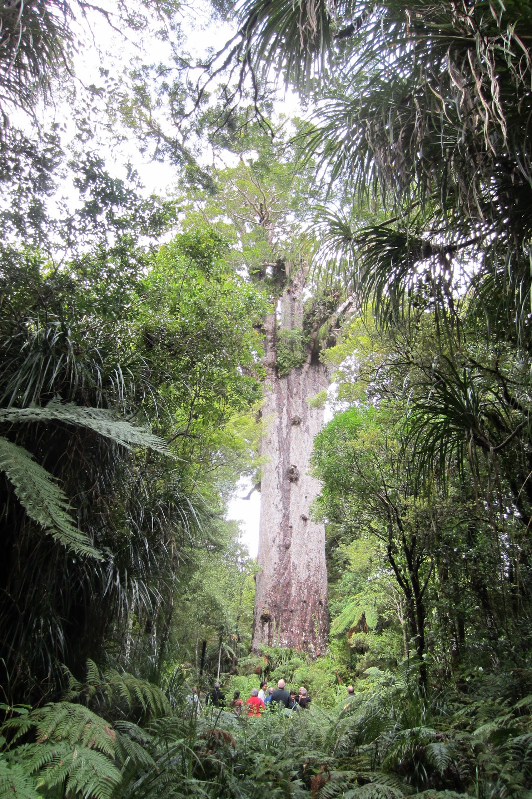
The Kiwi's love nature and the outdoors, and there are nine "Geat Walks" throughout the country.  These are 30 to 40-mile long nature trails that wind through some of the most beautiful, and unspoiled scenery in the world.  The Milford Track, the Routeburn Track, and the Kepler Track are considered three of the best, and are all reasonably close to Queenstown.  A lot of the scenes from the Lord of the Rings movies were filmed here, and some of it looks almost unreal.

I really want to do one of these, but my challenge is that it's a little early in the season, and the routes aren't officially open yet (though they are never formally closed).  There was a lot of late-season snow, and the avalanche risk-level is "extreme".  The Department of Conservation, or "DOC", manages the camping "huts" along the tracks, and advises against going out on the tracks at this time.  Besides that, however, there are no transportation services to the Milford or Routeburn trail-heads.  For example, if you wanted to do the Milford Track, you start with a half-hour bus ride from Te Anau to a boat dock on lake, then take an hour-long boat ride across the lake to the start of the trail.  The 33-mile trail ends in a wilderness area at the mouth of the Milford Sound, but you have to make private arrangements for a boat to pick you up there in advance - something like "meet me on the sand bar by the big rock on the left side of the mouth next Tuesday".  And then, you have to arrange for a ride back to Te Anau.  Well, with the avalanche warnings still in effect, none of these services are even operating.

The Kepler Track, however, is a 37-mile mountain loop that begins and ends at a trail-head right outside Te Anau.  It's designed as a 4 day hike through several mountain peaks, with overnight camping huts located at the end of each day's hike.   In the mountains, no camping is allowed outside of the huts, and you have to register a hiking plan with the DOC and buy a camping pass for each night in a hut.  The middle part of the track is impassable now due to snow, but, they say you can get to the first hut just below Mt. Luxmore.

It's 8.6 miles to the Luxmore hut, and the elevation is at 3,600 feet.  They say that it usually takes a fit hiker about 6 hours to cover the distance at a reasonable pace, but they also said that there was some "winter damage" on the trail near the tree-line, so it might take a bit longer.  Since this is my only option, I'm going to do an over-nighter.  Up to the Luxmore hut on day one, spend the night, and come back down on day two.  Since the trails aren't officially open, the hut is un-manned, and there is no water, electricity, or gas.  I have to pack-in and pack-out everything I'm going to need, and when I filed my plan with the DOC, there were only two other guys scheduled to be there for the night.   
     

The trail starts at lake-level, and for the first two hours, it's pretty easy going as you walk along the Fiordland National Park side of the lake.


Just past this beach, the trail goes into the forest, and up.  And up.  And up.


For the next six hours, every single step is up-hill.  Swithch-back after swithch-back, and the forest is so think that you can't see much more than tree trunks and the green canopy of leaves.  Then, I came upon this small opening.  The picture above is looking down on Te Anau.


Winter trail damage.  There are some improvements to the trails in the areas that are particularly dangerous, or see a lot of erosion.  The walkway is installed here because you're walking along a 45 degree slope - it's really, really steep.  Even though there are a lot of trees, if you lose you footing and fall, you could tumble down-hill for hundreds of yards.  It's not unusual here to have "tree-slides" along the cliffs where whole sections trees and vegetation come sliding down face of the mountain when the sheer gravity of their weight overcomes the ability of their root systems to hold on to the rock or land.  This one might not look so bad, but think about climbing over this muddy path by yourself with a 40 lb backpack, and knowing that it might be hours or days before someone else comes along to help you if you fall.


About 6 hours into the hike, I finally cleared the tree-line, and can see the top of Mt. Luxmore (4,600 ft).  You cannot imagine the scale. When I looked up, I thought "holy crap, it's going to take another 5 hours to get to the top of that".


Fortunately, the Luxmore hut was only another hour's hike away.  But, the trail was occasionally covered in waist-deep snow.


The huts are simple shelters.  A couple of dorm rooms with bunks and mattresses, chemical toilets, and a main room with a wood-burning stove for heat and 5 or 6 separate cooking stations that each have a sink and a stove with a couple of gas burners.  No showers, and since it's still early, the electricity, water, and gas haven't been turned on yet.

There were two French guys here when I arrived, and later on, a German couple showed up.  I had a bottle of wine with me, and the Frenchmen had some hard liquor.  We all cooked whatever we brought for dinner on our little camping stoves and had a great conversation.  It was pretty easy to get to sleep after nightfall.


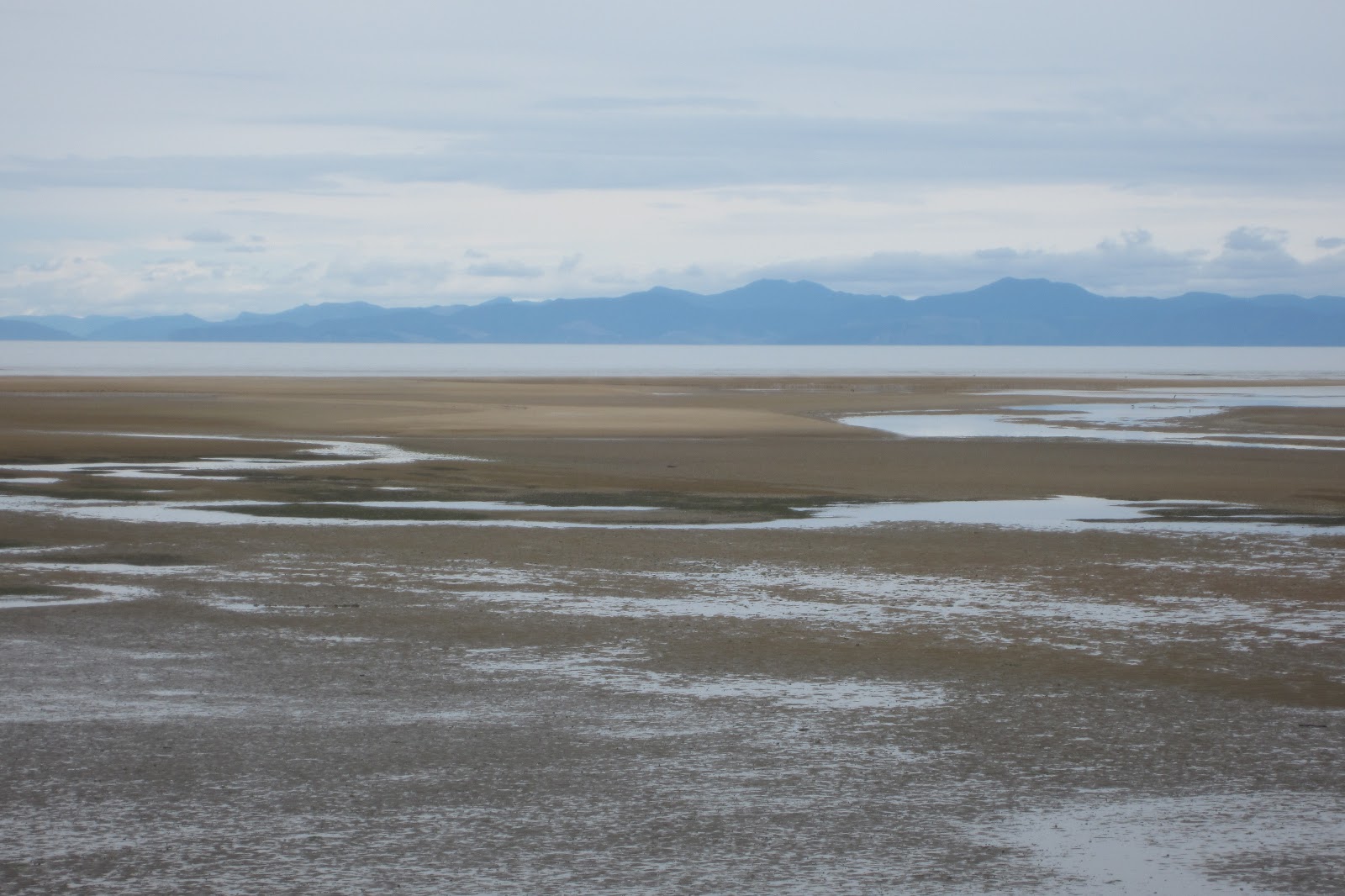
From the Luxmore hut, (above) this is where the South Fiord meets the main body of Lake Te Anau.  The Milford Sound is on the other side of the mountain range on the horizon.

The original Maori name for New Zealand is Aotearoa.  It means long white cloud.  After canoeing for hundreds of miles to get close to their destination, they looked for the long white clouds that you see on the horizon.  They didn't know that they were looking at snow-capped mountains. 


I hiked up above the hut (middle right), but this is about as far as I could go.  From here on, it's all snow.  Pretty stunning view, though, and well worth the effort.  I came back out later in the night to look at the stars, which were amazing.  

Wednesday, September 28, 2011

The Milford Sound


The next morning was gorgeous.


The Milford Sound is actually a fijord.  It's just over 10 miles long, and surrounded by sheer cliffs up to 5,000 feet tall.  While it opens to the Tasman Sea, that wasn't always the case.  It was actually a freshwater lake, and the western edge eroded into the sea.  The water that fills the sound has two layers - heavier freshwater on the bottom, and a lighter saltwater layer on the top.


I went on a small power-boat excursion this morning.  Our main vessel doesn't look very big compared to the sheer wall behind it, but the little yellow dots around it are people in kayak's.  The ship has sails, but the Captain said that they are really just for show.  


The mountains along the road to the Milford Sound are stunning.


Back in Te Anau, this is the view from my holiday park.


Tuesday, September 27, 2011

TeAnnu to the Milford Sound

The bus to the Milford Sound takes several hours, but the scenery is amazing.


The weather on the western side of the mountains is always unpredictable.  But it's a stunning place, even in the rain.


I'm doing an overnight boat tour on the sound, which lets you go out further and stay longer than the typical day-trip.  The boat holds about 60 people, so it's pretty big.  It was rainy and cold the first afternoon, but we had a big dinner, there's a bar, and they had a nice slide-show and movie about the area that night.


Monday, September 26, 2011

Te Anau

Te Anau is a small town of about 2,000 people, and is known as the gateway to the Milford Sound.  It's probably less than 100 miles from Queenstown as the crow files, but it takes about 4 hours to get there by bus.

This marks my first stop at a "holiday park", which is like a KOA campground on steroids.  They are very popular, and this place has 3 kinds of accommodation - tent sites, camper van sites that are powered, and these little single rooms.  I think I paid $30 for a night in this little box.


The holiday parks have shared bathrooms and showers, kitchens, common rooms with computers and tv's, and laundry rooms.  The cool part is that they are all very, very nice and incredibly clean.


This is Lake Te Anau.  It's cold and rainy today.  Heading to the Milford Sound tomorrow, so I hope that it gets better.